Hedges Are a Legal Document
The field pattern as a record of enclosure: what a straight hedge means, what a wavy one means, and how to read the date of a landscape from its boundaries.
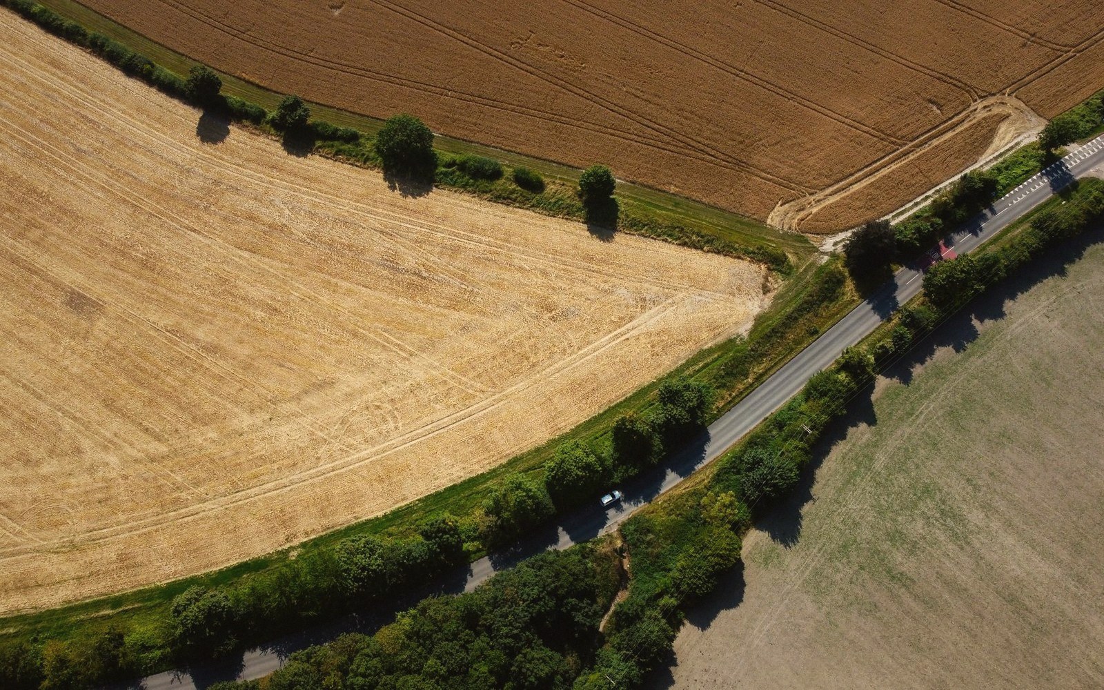
The boundary that was planted on purpose, and the one that was there already
A hedge is not just a field boundary. It is a written instrument — slower than parchment, but harder to lose. Every hedge in north Oxfordshire carries information about when it was planted, under what authority, and what kind of landscape it replaced. Learning to read that information is not difficult. It requires only a change of habit: stop looking at the view and start looking at the edge.
The basic distinction is between the planned and the accumulated. A straight hedge, running for hundreds of metres without deviation, marching at right angles to another straight hedge at the field corner — that hedge was planted in a single act, almost certainly under an Enclosure Act of Parliament. Parliamentary enclosure transformed the Midland landscape in a concentrated burst running roughly from the 1750s to the 1850s, and north Oxfordshire was in the thick of it. The county had been heavily farmed on the open-field system, where strips ran in great unfenced furlongs, farmed by individual householders but lying adjacent to one another without permanent boundary. When Parliament enclosed a parish, it granted each holder a consolidated block of land in exchange for their strips, appointed commissioners to lay out the new allotments, and required the new owners to fence or hedge their boundaries within a fixed period — typically a few years. The commissioners moved in with a surveyor's chain. The result is visible from any elevated road: regular, geometric, almost municipal.
Deddington, Adderbury, Bloxham, Hook Norton — parish after parish in this part of Oxfordshire went through enclosure between roughly 1760 and 1840. The award documents survive in the Oxfordshire History Centre in Oxford: long rolls of parchment specifying every new boundary, every new road, every new drainage ditch, down to the rod and perch. The hedges those documents authorised are still growing. When you see a hawthorn line so straight it might have been drawn with a ruler, you are looking at the commissioners' surveyor at work.
What the wavy hedge remembers
The crooked hedge tells a different story. Boundaries that curve gently for no obvious topographic reason — following no stream, skirting no hillside — are usually following something that was already there before anyone put a hedge on it. Most often, they are tracing the edge of a strip or a furlong from the pre-enclosure open fields. When a farmer in the medieval period accumulated enough adjacent strips to farm them as one piece, he might mark the outer edge with a hedge or a bank; the resulting boundary reflected the shape of the strips it consolidated, not the logic of a surveyor's line. Some of these early enclosures happened piecemeal, over centuries, by agreement between neighbours rather than by Act of Parliament. Their field shapes are accordingly irregular: fields that widen at one end, fields with slightly kinked boundaries, odd triangular corners that remember a junction in the old strip system.
Banks matter here, too. An old hedge — older than the parliamentary enclosure period — is commonly set on an earthen bank, sometimes with a ditch alongside it. This raised platform is partly practical (it improved drainage and gave the hedge roots a dry purchase) and partly social (a bank was the physical marker that said this is the line). The banks of ancient boundaries can still be found on the margins of surviving old woodland, or at the edges of parishes where the agricultural pressure to sweep them away was lower. Run your eye along the base of a hedge rather than its top. If there is a raised linear mound beneath it, the boundary is probably older than any enclosure act. Some such banks in this part of England are medieval; a few may be earlier still.
The species in a hedge confirm or qualify the picture. The ecologist's rule of thumb — commonly attributed to Dr Max Hooper's work in the 1970s, though the method has always been a rough guide rather than a precision instrument — holds that the number of woody species in a thirty-metre length of hedgerow approximates to the hedge's age in centuries. One species: planted recently, almost certainly hawthorn, probably enclosure-era. Five or six species — field maple, hazel, spindle, elder, blackthorn, crab apple mixed through the hawthorn — suggests a much longer history. The method is imprecise, affected by soil type, aspect, and management history, and should be used alongside, not instead of, the map evidence. But a hedge dense with field maple in this part of Oxfordshire is asking to be taken seriously as something old, and the question worth asking is: old in relation to what boundary?
Five or six species — field maple, hazel, spindle, elder, blackthorn, crab apple mixed through the hawthorn — suggests a much longer history.
- Pre-parliamentary enclosurepiecemeal, by agreement, over centuries from roughly the medieval period onward; produces curved, irregular boundaries
- Parliamentary enclosure peakroughly 1750s to 1850s in Oxfordshire; produces straight, geometric hedges and wide new roads
- Hooper's hedgerow dating rulework formalised in the 1970s; one woody species per thirty metres approximates one century of age, treated as a rough guide only
- Ironstone extraction (19th–early 20th century)disrupted pre-existing field patterns in parts of north Oxfordshire, creating gaps in the hedge record
Reading the whole field pattern at once
The real technique is to read not one hedge but the pattern formed by all of them. Aerial photographs, and now the satellite imagery available to anyone at a desk, reveal the palimpsest quality of the enclosure landscape immediately: regular rectangular blocks interrupted by curved anomalies, which are themselves interrupted by roads whose lines predate both. The irregular patches are frequently the ghost of the old furlongs or the old greens. A roughly oval enclosure with gently curving sides, sitting within a grid of parliamentary fields, is often all that remains of a former common or a roadside waste, absorbed into private ownership at some point but never quite losing the shape that grazing animals and time had given it.
The roads compound the evidence. Parliamentary enclosure awards typically created new roads, laid out straight and wide — forty feet was a common carriage road width, with additional verges. These roads cut through the new field pattern at angles that served the new owners, not the medieval village plan. Their verges, never ploughed, are consequently some of the most species-rich grassland in the district: old grassland plants, including various orchid species, persist in them precisely because the plough stopped at the hedge line. The verge of an enclosure road is a tiny nature reserve with a legal origin in a specific Oxfordshire Act of Parliament.
The ironstone belt that runs through this district adds one further complication to the reading. Where quarrying cut into the field pattern — as it did at various points across north Oxfordshire during the nineteenth and early twentieth centuries, when ironstone extraction was briefly industrial in scale — hedges were rooted out and later reinstated, or never reinstated at all, leaving large open areas that can be mistaken for very late enclosure when they are in fact the scar of extraction followed by agricultural amalgamation. Knowing that the ground under a field may once have been quarried changes how you read the absence of old boundaries within it.
Taken together, the hedges of north Oxfordshire constitute something close to a continuous archive. Parliamentary enclosure documents in an archive box; field maple thickening through a hedge that was old when those documents were being written; a bank that predates both; a road verge that is the unintended consequence of a surveyor's chain two centuries ago — each layer legible if you know what you are trying to read. The hedge that seems to divide one field from another is simultaneously dividing one century from another. That is what makes it a document.